Gps for trails
#11
 03-21-2012, 04:05 AM

I use the Garmin GPSMAP76 with installed 100K level basemaps and always have at least one paper map and know reasonably well where I am. The "knowing where I am" comes from a line of work where it's required, so it's a routine. I may rely on the gps up to 90% of the time, but if it fails, I can pull out the map and quickly pinpoint where I am. The gps is RAM-mounted to the handlebars nearly all the time to whatever I'm riding off road.
I've had troubles with more than one of the cheaper etrex models. The 76 has taken many tough spills, has many scratches, and keeps on trucking.
The Map76 is a larger gps than many, but it's a marine design so it floats (large form-factor for the mass). I've used multiple Garmin units in my line of work since the 12 and 12XL were typical standards, and Trimble stuff before the military turned off the scramble (mid 1990's I think). I'm experienced with dropping GPS units in the river and not necessarily being able to retrieve them, so a floating receiver is a must to me. YRMV
Last edited by IDRIDR; 03-21-2012 at 04:10 AM.
#13
03-21-2012, 01:42 PM
eTrex Legend with neoprene case, clipped to my tailbag. The Garmin handlebar mount is too rigid. It will bounce the batteries and shut the unit off. It happened to me. Only does it off-road, in rougher terrain.
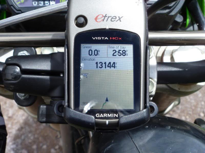
I would NOT rely on a phone where I ride. Yes, they "SAY" it has a "GPS" in it, but if my phone can't get a signal, the GPS doesn't work either. Most phones use more of a pseudo-GPS function that relies on cell towers to triangulate position. See that big patch antenna on the eTrex... try fitting THAT inside a phone... ain't gonna happen. Use a REAL GPS!
I would NOT rely on a phone where I ride. Yes, they "SAY" it has a "GPS" in it, but if my phone can't get a signal, the GPS doesn't work either. Most phones use more of a pseudo-GPS function that relies on cell towers to triangulate position. See that big patch antenna on the eTrex... try fitting THAT inside a phone... ain't gonna happen. Use a REAL GPS!
#14
03-21-2012, 01:53 PM
I have a Magellan 5000...lets you take a picture where you are,and brings you back to that spot..about 3yrs old 600 bucks...no Ididn't pay that...in box got it brand new 100 bucks never used...CL is the best place to find anything...CHEAP
#16
03-21-2012, 04:11 PM
All you really need to do is mark a waypoint for where your start point is. I keep if off most of the time and only turn it back on to point me back to where I need to go. This works great in a wide open desert. On trails I would keep it on and use the trackback.
#17
03-21-2012, 04:40 PM
.....tsk, tsk. You guys and your battery-operated toys. Weren't you ever in Boy Scouts?? Just strap on one-a-deez and pay attention. 
(I am not completely serious, however, I always pack a compass and know how to use one....infinitely better than a GPS thingy.) Once an Eagle Scout, always an Eagle Scout.
(I am not completely serious, however, I always pack a compass and know how to use one....infinitely better than a GPS thingy.) Once an Eagle Scout, always an Eagle Scout.
#18
03-21-2012, 05:23 PM
I would NOT rely on a phone where I ride. Yes, they "SAY" it has a "GPS" in it, but if my phone can't get a signal, the GPS doesn't work either. Most phones use more of a pseudo-GPS function that relies on cell towers to triangulate position. See that big patch antenna on the eTrex... try fitting THAT inside a phone... ain't gonna happen. Use a REAL GPS!
#19
03-21-2012, 05:24 PM
.....tsk, tsk. You guys and your battery-operated toys. Weren't you ever in Boy Scouts?? Just strap on one-a-deez and pay attention.
(I am not completely serious, however, I always pack a compass and know how to use one....infinitely better than a GPS thingy.) Once an Eagle Scout, always an Eagle Scout.
(I am not completely serious, however, I always pack a compass and know how to use one....infinitely better than a GPS thingy.) Once an Eagle Scout, always an Eagle Scout.
When you're really in the sticks in a place you've never been before, the compass won't always answer your question...well...maybe it will eventually. I'm an ex-backpacker too, so I'm used to using maps and a compass. However, here's the problem you run into when riding in the real outback with just a map and compass. You come to a fork in the singletrack or 2-track. You look at your map, and it shows only one trail at this location. Over years, off roaders have created an undocumented spur that goes somewhere else...and maybe not where you want/need to go at the moment. Yes, you will eventually find that you took the correct or incorrect arm of the spur, but how much fuel and time did you waste doing so? This happens more times than I like, and sometimes it can mean the difference between running out of gas and/or running out of daylight. When you have plenty of time and fuel, these unexpected side excursions can be the best part of the day's ride. In other situations it could mean a cold, hungry night out in the boonies trying to figure out what your next move is with no fuel and walking out with MX boots. A GPS in this situation can in short order confirm where you are on the installed topo map, and you can tell for sure you're headed where you need to go.
Just saying that a GPS for those who really like to get off the beaten path can be an invaluable tool...and maybe a lifesaver. Like I said, I actually keep mine in my pack until such a situation arises, because I love to use maps. Sometimes, however, it's better to be safe than sorry.
#20
03-21-2012, 05:39 PM
(Point well-taken.)
TNC, I live in SW Ohio. Go any direction for 10 miles and you'll hit a highway or small town. As much as I would love to get lost in the wilderness (as I used to many years ago,) I'm lucky to get out of state let alone "Out-back."
TNC, I live in SW Ohio. Go any direction for 10 miles and you'll hit a highway or small town. As much as I would love to get lost in the wilderness (as I used to many years ago,) I'm lucky to get out of state let alone "Out-back."