
DEEJ, NEED DIRECTIONS


Thread Starter
|
Junior Member
Joined: Apr 2006
Posts: 9
From:
Deej, I know you live in Forks so maybe you can help me out. A friend is coming up in the spring and I want to take him for a ride along the coast from Ocean Shores to the Hood Canal. I have ridden on the beach from Ocean Shores to the Quinault Reservation and my question is, how far can a person ride along the coast, riding on the beach and or fire roads? I know I have to get off for clam beds, state parks, etc., but I want to see as little asphalt as possible. Thanks for any information in advance and if we can meet in Forks, lunch is on me.
Your Humble Moderator/Admin
Joined: Nov 2005
Posts: 21,060
From: Washington
1st Gear Member
Hey Jack, the only place you can ride on the beach is Long Beach, up here its either Park or Indian reservation. As far as fire roads, I am believe it or not re-discovering by own back yard since getting the KLX. I am planning a ride from my house over the mountain to the Mary Clark Road (30 miles), then jumping across the highway and up to Snyder Lookout (10 miles), and then down the back side to Highway 112, (16 miles) and then to Neah Bay (Indian reservation to the tip of the Peninsula of Washington, (20 more or so) Somewhere there is a road that a parson can take to get from Forks to Lake Ozette, Funny Rayonier Timber Land Company just had a 60 person 1 day conference at our facility and I saw the guy that runs the office here in Forks, and I was going to ask him how to get there. Here is a picture of the peninsula. How far were you planning on riding?
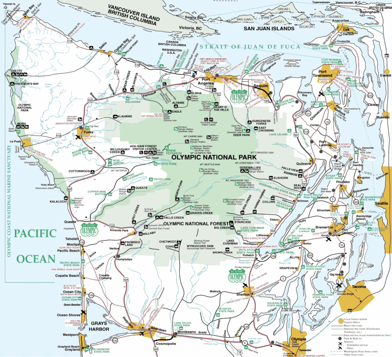
Here is a bigger version: http://www.youra.com/destinations/ma...ccolormap.html
OK in checking for maps I just found the coolest website for peninsula maps, and if you hadn't asked the question I would have never found it so thanks. Check it out. Keep me informed and maybe if you make it this far I will join up. http://www.youra.com/maps/index.html
Thread Starter
|
Junior Member
Joined: Apr 2006
Posts: 9
From:
Great maps, thank you very much. The plan is to loop from Ocean Shores to Hood Canal. I'm in Poulsbo so we may reverse the loop and end in Ocean Shores. Planning on taking 2-4 days. No hurry, just explore and take pictures. BTW, I met an older gentelman In Ocean Shores who said their are fire roads from Taholah all the way to the Hood Canal. I don't know if that is true or not but it sure would be a great ride. Once again, thank you for the maps, I will be using them more than you can imagine.

Thread
Thread Starter
Forum
Replies
Last Post